Abstract
The Qinzhou Chenzhou Fault Zone is the junction zone between the Huaxia Block and the Yangtze Block. It is of great significance for how geothermal resources are controlled and for in-depth research on structural heat control. Starting from geothermal geological analysis, this article systematically analyzes and studies the types of thermal reservoirs, hot spring distribution, spring temperature field distribution, spring flow field distribution, and spring chemical field distribution on both sides of the Qinzhou Chenzhou Fault Zone. The results indicate that the Qinzhou Chenzhou fault zone has a significant controlling effect on geothermal resources in the Hunan Guangxi region. The northwest side of the fault zone is dominated by sedimentary thermal reservoirs, while the southeast side shows a decrease in the distribution of sedimentary thermal reservoirs, which is basically equivalent to intrusive rock structure thermal reservoirs; The anomalous thermal field of the springs is distributed along the Qinzhou-Chencheng fault zone, with a significant difference in the density of hot springs on either side of the fault, The density of hot springs on the northwest side of the fault zone is 1.18/104km2, which is lower than that on the southeast side, which is 3.69/104km2; The chemical correlation coefficients of the three high-temperature hot springs are 0.78-0.8.
|
Published in
|
American Journal of Energy Engineering (Volume 14, Issue 1)
|
|
DOI
|
10.11648/j.ajee.20261401.15
|
|
Page(s)
|
34-44 |
|
Creative Commons
|

This is an Open Access article, distributed under the terms of the Creative Commons Attribution 4.0 International License (http://creativecommons.org/licenses/by/4.0/), which permits unrestricted use, distribution and reproduction in any medium or format, provided the original work is properly cited.
|
|
Copyright
|
Copyright © The Author(s), 2026. Published by Science Publishing Group
|
Keywords
Qinzhou Lingshan Tectonic Belt, Linwu Chenzhou Fault, Thermal Storage Type, Temperature Field, Flow Field
1. Introduction
The total amount of hydrothermal geothermal resources in China is equivalent to 1.25 trillion tons of standard coal, with an annual exploitable amount equivalent to 1.9 billion tons of standard coal, accounting for 44% of the country's total energy consumption in 2015
| [1] | Wang Guiling, Liu Yanguang, Zhu Xi, Zhang Wei. Current Status and Development Trends of Geothermal Resources in China [J]. Earth Science Frontiers, 2020, 27(01): 1-9. |
| [2] | Ren Hujun. Progress and Prospects in the Development and Utilization Technology of Medium-Deep Geothermal Energy [J]. China Coal Geology, 2020, 31(S1): 9-11+60. |
[1, 2]
.
Dry hot rock is widely distributed within the Earth's interior, but exploitable dry hot rock resources are primarily found in areas with recent volcanic activity, regions with thin crust, and along the edges of tectonic plates or structural bodies. In China's continental regions, the estimated resource volume of dry hot rock at depths of 3 to 10 kilometers underground is equivalent to 856 trillion tons of standard coal. According to international standards for dry hot rock, with 2% classified as recoverable resources, it amounts to approximately 4,000 times the total energy consumption of the nation in 2015
| [1] | Wang Guiling, Liu Yanguang, Zhu Xi, Zhang Wei. Current Status and Development Trends of Geothermal Resources in China [J]. Earth Science Frontiers, 2020, 27(01): 1-9. |
[1].
1.1. Challenges in the Development of Geothermal Energy
Although China is rich in geothermal resources, the development of geothermal energy faces significant challenges.
1) The formation mechanism of geothermal energy remains unclear
| [3] | Jiang Xiangming. Dual Development Opportunities for the Coal Industry and Geothermal Sector under the "Dual Carbon" Goals [J]. China Coal Geology, 2022, 34(S1): 1-6. |
[3]
. The interaction and coupling mechanisms among factors such as the geothermal heat flux, thermal reservoir systems, heat-controlling factors, and crustal activity require further research.
The Pearl River must be translated as "the Pearl River."
2) The exploration level of geothermal resources is low and the family background is unclear.
| [1] | Wang Guiling, Liu Yanguang, Zhu Xi, Zhang Wei. Current Status and Development Trends of Geothermal Resources in China [J]. Earth Science Frontiers, 2020, 27(01): 1-9. |
[1].
The survey accuracy of geothermal resources in most areas of China is only 1:1000000, with only Tianjin, Beijing, Lubei Plain, Guanzhong Basin, Qinghai Tibet Railway and the Pearl River Delta reaching the accuracy of 1:25000, and a few geothermal fields, such as Yangbajing, Yangyi, Xiongxian and other individual geothermal fields reaching the accuracy of 1:50000. There is little or no formal geothermal exploration work carried out in key geothermal development zones.
3) The degree of geothermal development and utilization is low, and the forms are singular
| [1] | Wang Guiling, Liu Yanguang, Zhu Xi, Zhang Wei. Current Status and Development Trends of Geothermal Resources in China [J]. Earth Science Frontiers, 2020, 27(01): 1-9. |
| [4] | Wang Guiling, Zhang Wei, Liang Jiyun, Lin Wenjing, Liu Ziming, Wang Wanli. Evaluation of Geothermal Resource Potential in China [J]. Acta Geoscientia Sinica, 2017, 38(04): 449-450+134+451-459. |
| [5] | Wang Guiling. Strategic Research on Geothermal Resource Exploration and Evaluation in China [C]. China's Geothermal Energy: Achievements and Prospects - Proceedings of the 40th Anniversary Commemorative Conference for Li Siguang's Advocacy of Geothermal Energy Development and Utilization and the China Geothermal Development Symposium, 2010: 55-62. |
| [6] | Tian Yong, Wang Weimin, Zhao Yan. Comprehensive Utilization of Geothermal Resources in the Beijing-Tianjin-Hebei Region [J]. China Coal Geology, 2020, 32(02): 51-58. |
[1, 4-6].
There is no tiered development and utilization.
4) Key technologies require innovation, and equipment remains outdated
| [3] | Jiang Xiangming. Dual Development Opportunities for the Coal Industry and Geothermal Sector under the "Dual Carbon" Goals [J]. China Coal Geology, 2022, 34(S1): 1-6. |
[3]
.
5) The monitoring network is not well-established
| [1] | Wang Guiling, Liu Yanguang, Zhu Xi, Zhang Wei. Current Status and Development Trends of Geothermal Resources in China [J]. Earth Science Frontiers, 2020, 27(01): 1-9. |
[1].
Therefore, studying the formation mechanisms and resource distribution characteristics of geothermal energy is of great significance for the development and utilization of geothermal resources.
1.2. Strategic Position of Geothermal Energy
1) In terms of energy efficiency in urban and rural buildings
| [3] | Jiang Xiangming. Dual Development Opportunities for the Coal Industry and Geothermal Sector under the "Dual Carbon" Goals [J]. China Coal Geology, 2022, 34(S1): 1-6. |
[3]
. Shallow geothermal energy (burial depth less than 200m, medium shallow geothermal energy (burial depth less than 200m~500m), medium deep and low temperature geothermal energy (500m~3000m, temperature less than 100°C) heat pump technology and system will replace traditional building heating and cooling systems as the energy source for heating and cooling.
2) In terms of electricity and energy. Constructing geothermal power stations using mid to high temperature geothermal energy in areas with good geothermal geological conditions, and establishing dry hot rock power stations in areas with well-developed dry hot rocks, partially replacing traditional fossil fuel power generation.
3) Cascade utilization of geothermal resources
| [3] | Jiang Xiangming. Dual Development Opportunities for the Coal Industry and Geothermal Sector under the "Dual Carbon" Goals [J]. China Coal Geology, 2022, 34(S1): 1-6. |
[3]
. In excellent geothermal resource areas, a cascade utilization chain of geothermal resources such as power generation, heating, bathing, agriculture, and industrial drying can be established to maximize the comprehensive utilization rate of geothermal resources.
4) Explore the potential of renewable energy heating resources, scientifically layout geothermal energy heating, strengthen the cascade utilization of geothermal energy, develop heating modes that directly use green electricity such as direct connection of green electricity according to local conditions, actively explore the complementary and efficient utilization of multiple heat sources such as geothermal energy, wind and solar energy, biomass, and traditional fossil energy, and promote the organic integration of new energy heating and existing heating systems
| [7] | National Energy Administration. Guidelines of the National Energy Administration on Promoting the Integrated and Integrated Development of New Energy (State Energy Administration Document No. 93 [2025]. |
[7]
.
1.3. Thermal Control Structure
Thermal control structures can be divided into four categories based on their genesis: heat generating structures, heat conducting structures, heat storage structures, and heat releasing structures.
1) Thermal structure. It refers to the structure that provides a core heat source for geothermal resources. Typical heat generating structures include mantle asthenosphere diapirs, magma chambers containing highly radioactive elements, active deep faults, and related structures formed by plate subduction and collision movements, which can also generate heat energy and are the "source of heat" for geothermal resources
| [8] | Xiang Song, Golden Water, Wu Bingcheng Mantle convection structural model and its implications for the evolution of Earth's surface structures: a three-dimensional numerical simulation study [J]. Chinese Science: Earth Sciences, 2025, 55(01): 272-298. |
| [9] | Luo Fan, Yan Jiayong, Zhang Sheng, etc Thermal structural characteristics and structural indicators of the lithosphere in the South China Block and adjacent areas [J]. Geological Bulletin, 2024, 43(11): 2028-2043. |
| [10] | Song Tao, Diao Qian, Zhen Yunqing The relationship between geothermal resources and mantle plume structures in the Qinghai Tibet Plateau: multi-stage evolution of mantle plumes leading to magma intrusion into shallow heat sources [J]. Journal of Hebei University of Geosciences, 2018, 41(06): 1-24.
https://doi.org/10.13937/j.cnki.hbdzdxxb.2018.06.001 |
[8-10].
2) Thermal conductivity structure. It refers to the structures that undertake the role of thermal energy transfer, mainly including brittle ductile transition zones and active ductile shear zones in the middle and lower crust. These structures can efficiently transfer the heat generated by heat generating structures to heat storage or release structures, and are the "key channels" for thermal energy transfer
| [8] | Xiang Song, Golden Water, Wu Bingcheng Mantle convection structural model and its implications for the evolution of Earth's surface structures: a three-dimensional numerical simulation study [J]. Chinese Science: Earth Sciences, 2025, 55(01): 272-298. |
| [11] | Yan Zhenzhi, Li Shijiang, Chu Guigang Analysis of Thermal Control Structures in Anshan Tanggangzi Geothermal Field [J]. Geological Exploration Discussion Series, 2003, (S1): 29-31. |
| [12] | Xiang Wei Analysis of the Origin and Development Utilization of Geothermal Resources in Sanqiao Area, Guiyang City [J]. Western Resources, 2019, (05): 115-116.
https://doi.org/10.16631/j.cnki.cn15-1331/p.2019.05.048 |
| [13] | Ye Hongen Exploration of the correlation between geothermal resources, hydrothermal and dry heat systems [J]. Earth, 2019, (06): 102. |
[8, 11-13].
3) Thermal storage structure. It refers to the fracture system in thermal storage, cap rocks, and thermal storage rock masses, that is, the structure that retains heat. The low resistance and high conductivity of the middle and lower crust, as well as the ductile shear rheological layer, have dual characteristics of thermal conductivity and storage, which can stably store the heat energy transmitted and ensure the scale and thermal stability of geothermal resources
| [14] | Wang Chengming, Yang Xunchang, Xu Yong, etc Isotope characteristics analysis of geothermal water in deep karst reservoirs in Shandong Province [J]. Shandong Land and Resources, 2013, 29(01): 21-24. |
| [15] | Zhang Senqi, Li Changhui, Sun Wangyong, etc Establishment of Conceptual Model for Thermal Reservoir Structure in Xining Basin [J]. Geological Bulletin, 2008, (01): 126-136. |
[14, 15]
.
4) Thermal structure. It refers to structures that release thermal energy to the shallow surface, such as volcanoes, earthquake related structures, and shallow level active faults
| [16] | Zhou Xiaocheng, Zeng Zhaojun, He Miao, etc The characteristics of short-term precursor anomalies of Tengchong volcanic hot spring fluid geochemistry earthquakes [J]. Earthquake Research, 2026, 49(01): 51-64.
https://doi.org/10.20015/j.cnki.ISSN1000-0666.2026.0006 |
| [17] | Su Xiaoyi, Gu Guohui, Pan Xiaodong, etc Characteristics of Carbon Gas Flux near the Tianchi Volcanic Hot Springs in Changbai Mountain [J]. Journal of Disaster Prevention and Reduction, 2025, 41(01): 82-89.
https://doi.org/10.13693/j.cnki.cn21-1573.2025.01.011 |
[16, 17]
, which can gradually release stored geothermal energy outward, forming phenomena such as hot springs and thermal storage outcrops
| [18] | Chen Yue, Zhu Jinlin, Zeng Jinjin, etc The distribution pattern and controlling factors of hot springs in the complex tectonic zone of Shaoguan, Guangdong [J]. Journal of Chengdu University of Technology (Natural Science Edition), 2023, 50(01): 101-110. |
| [19] | Song Yin Research on the Characteristics and Causes of Longling Hot Springs in Yunnan Province [D]. Kunming University of Science and Technology, 2021.
https://doi.org/10.27200/d.cnki.gkmlu.2021.000793 |
[18, 19].
Thermal control structures can be classified into structural systems, structural systems, primary fault zones, secondary fault zones, and secondary fault zones according to their levels.
1) Construct a system. The structural system controls the overall distribution trend of geothermal temperature in China, namely the ancient Asian fault system<the Pacific Rim fault system<the Tethys Himalayan fault system. The tectonic system controls the distribution of geothermal basins (zones), which in China can be divided into four types: southwest high temperature geothermal zones, eastern medium low temperature tropical and hot basins, northern cold basins, and junction warm basins
| [20] | Yang Sennan, Yang Weiran Regional Geodesy in China [M]. Beijing: Geological Publishing House, 1985. |
| [21] | Zhang Jian, He Yubei, Fan Yanxia, etc Crustal Temperature of the Southern Section of the Tanlu Fault Zone: Geothermal Analysis Based on High Resolution Three Dimensional Velocity Model [J/OL]. Geological Frontier, 1-12 [2021-11-25]
https://doi.org/10.13745/j.esf.sf.2025.3.76 |
| [22] | Xu Shihong, Zhong Jianhua, Xu Youde, etc Differences in Depression, Source Rocks, and Hydrocarbon Evolution on Both Sides of the Tan Lu Fault Zone [J]. Journal of Chengdu University of Technology (Natural Science Edition), 2007, (05): 505-510. |
[20-22]
.
2) Fault zones, primary fault zones control the distribution of geothermal field types; Secondary fault zones control the distribution of geothermal fields; The secondary fault zone controls the exposure of hot springs.
1.4. Research Objectives
The four major conditions of heat source, reservoir, channel, and cap are related to the formation of geothermal energy, especially the main controlling factors of source, reservoir, and channel. The Qinzhou Chenzhou fault zone is the contact zone between the Huaxia block and the Yangtze block. Hu Huaxuan et al.
| [23] | Hu Huaxuan, Qin Ya, Wu Jie, etc The structural properties of the Yingyangguan Group in northeastern Guangxi: Chronological constraints from the banded magnetite quartzite of the Halong Formation [J/OL]. East China Geology, 1-26 [2020-08-22] https://doi.org/10.16788/j.hddz.32-1865/P.2025.01.007 |
[23]
proposed that the Yingyangguan Group in northeastern Guangxi belongs to the Neoproterozoic, and its tectonic evolution is closely related to an extensional rift setting. The banded magnetite quartzite of the Long Formation within the Yingyangguan Group is mainly derived from the recycling of Meso - to Paleoproterozoic and Archean materials. These are predominantly products of the Neoproterozoic magmatic events of the Yangtze Block, with a minor contribution of Grenvillian-age and Late Archean detrital materials sourced from the Cathaysia Block.Li Shuai et al.
| [24] | Li Shuai, Wang Fan, Wang Jinchao, etc The characteristics of intra plate deformation and structural transformation in the Qinzhou Lingshan tectonic belt of the southern section of the Qinhang Hangzhou junction zone during the Mesozoic era [J]. Geotechnical and Mineralogy, 2023, 47(03): 523-534.
https://doi.org/10.16539/j.dgzyckx.2023, 03.004 |
[24]
suggested that the Lingshan Fault is not a typical crustal fault, but rather an oblique collisional suture zone between the Yangtze and Cathaysia plates in Guangxi.However, comprehensive studies on the relationship between this fault zone and geothermal resources remain scarce. Peng Touping et al.
| [25] | Peng Touping, Li Chaowen, Peng Bingxia Structural constraints and exploration indicators of geothermal resources in Hunan Province [J]. Hunan Geology, 2002, (01): 56-60. |
[25]
proposed that the Linwu-Chenzhou Fault controls the distribution of hot springs along the Anren-Chenzhou-Linwu geothermal anomaly belt. These springs are predominantly medium- to low-temperature thermal springs, occurring in a beaded pattern along active strike-slip faults.Among them, medium-temperature hot springs are mainly distributed at the intersections of the Leiyang-Linwu N-S compressional faults and NE-trending faults, while low-temperature hot springs are primarily concentrated in the Anren-Chenzhou area.Wang Xinwei et al.
| [26] | Wang Xinwei, Zhang Lili, Li Shanmin Analysis of the genesis model of Yangmeichong geothermal field in Guangxi [J]. Chinese Karst, 2024, 43(04): 876-888+921. |
[26]
and Wu Weizhi et al.
| [27] | Wu Weizhi, Mo Yanjuan, Huang Lixia, etc The formation conditions and hydrochemical characteristics of Hetang Hot Springs in Hezhou [J]. Journal of Guangxi Academy of Sciences, 2013, 29(04): 230-234.
https://doi.org/10.13657/j.cnki. gxkxyxb.2013.04.05 |
[27]
proposed that both the Yangmeichong Geothermal Field in Hezhou and the Datang Geothermal Field in Nanxiang Town are belt-shaped geothermal reservoirs, where deep-seated faults serve as channels for deep circulation and as structures that confine and store the subsurface thermal waters.Starting from the perspective of regional heat-controlling structures, this study analyzes the distribution pattern, temperature characteristics, and hydrochemical field features of geothermal reservoirs along the Qinzhou-Chenzhou Fault Zone.Conducting research on the characteristics of geothermal resources is of great significance for enhancing the development and utilization of geothermal resources in the central and southern regions of China.
2. Geological Exploration Methods
Geothermal resource investigation is a conventional method in geothermal resource exploration, including data collection and analysis, tool and material preparation, and field surveys. The main parameters measured on-site at hot springs include location and elevation, temperature, flow rate, etc. Hot spring temperatures are typically measured with portable thermometers, with 2-3 tests conducted and the average value taken. Spring flow rates are generally measured using the volumetric method or weir method. The hydrochemical characteristics of hot spring water are determined through field sampling and tested by specialized water quality testing agencies. Comprehensive analysis indicators include major anions and cations (HCO3-, Cl-, SO42-, CO32-, K+, Na+, Ca2+, Mg2+), trace elements and special components (F, Br, I, SiO2, B, H2S, Al, Pb, Cs, Fe, Mn, Li, Sr, Cu, Zn, etc.), radioactive elements (U, Ra, Rn), as well as total α and β radioactivity, pH value, total dissolved solids, hardness, and oxygen consumption. The characteristics of the thermal reservoir are primarily obtained through geothermal well data and geological and hydrogeological data. This study investigated and collected data from 47 springs and 6 geothermal wells.
Indoor analysis methods mainly include cluster analysis, analytic hierarchy process, and other methods.Cluster analysis refers to the process of grouping a collection of physical or abstract objects into multiple classes composed of similar objects. By combining geological condition analysis and Analytic Hierarchy Process, 12 indicators including temperature, pH value, total dissolved solids, K
+, Na
+, Ca
2+, Mg
2+, Li, HCO
3-, Cl
-, SO
42-, and F were determined for 53 samples. Use equation (
1) for nondimensionalization.
In the formula: xij 'is the jth index value of the i-th sample; Xj is the mean of the jth indicator; Sj is the standard deviation of the jth indicator.
Calculate the correlation coefficient using equation (
2).
(2)
In the formula, Cnm is the correlation coefficient between the nth sample and the mth sample; Xj is the dimensionless mean of the jth indicator.
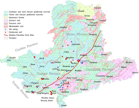
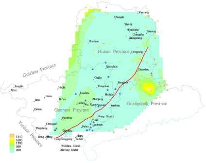
3. Qinzhou-Chenzhou Fault Zone
The Qinzhou-Chenzhou Fault Zone originates in Dexian’an, Vietnam
| [28] | He Jun, Liu Huaiqing, Li Qinghua, etc Preliminary exploration of the activity of the Lingshan section of the northeast branch of the Fangcheng Lingshan fault zone in Guangxi [J]. South China Geology and Mineral Resources, 2012, 28(01): 71-78. |
[28]
, and extends through Fangcheng, Qinzhou, Lingshan, Da’an in Pingnan, Hezhou, Linwu, Chenzhou, Yongxing, and Anren before entering Jiangxi Province, the fault zone stretches 800 km within Guangxi and Hunan provinces. Its western section corresponds to the Qinzhou-Lingshan structural belt, the central section to the Tengxian North-Hezhou structural belt, and the eastern section to the Linwu-Chenzhou Fault Zone (
Figure 1).
The Lingshan segment of the Qinzhou-Lingshan structural belt
| [24] | Li Shuai, Wang Fan, Wang Jinchao, etc The characteristics of intra plate deformation and structural transformation in the Qinzhou Lingshan tectonic belt of the southern section of the Qinhang Hangzhou junction zone during the Mesozoic era [J]. Geotechnical and Mineralogy, 2023, 47(03): 523-534.
https://doi.org/10.16539/j.dgzyckx.2023, 03.004 |
[24]
is mainly composed of three tectonic systems formed during different geological periods and characterized by distinct structural properties: the Lingshan strike-slip structure, the Luoyangshan thrust-nappe structure, and the Lemin-Zhaiwei extensional structure.The Lingshan strike-slip structure exhibits a reverse-transcurrent nature. In plan view, it is characterized by a set of parallel or branching composite fault zones, while in cross-section, it displays a positive flower structure that converges at depth.The Luoyangshan thrust-nappe structure is characterized by the overthrusting of the Luoyangshan granite onto Paleozoic strata. In plan view, it forms a northwest-convex arcuate composite fault zone, while in cross-section, it consists of a fore- and back-edge thrust-type ductile shear zone interspersed with granite fault slivers.The Lemin-Zhaiwei extensional structure consists of a ductile shear zone at the top of the granite core, a set of tensional dike swarms, and major extensional fault zones
| [29] | Wang Jincao, Li Shuai, Huang Guanwen, etc The Geotechnical Significance of the Lingshan Fault Zone in Guangxi: Evidence of the Diagonal Collision between the Yangtze Plate and the Huaxia Plate [J]. Journal of Guilin University of Technology, 2017, 37(04): 738-739. |
[29]
.The eastern and western branches of the Lingshan segment of the Fangcheng-Lingshan Fault Zone have remained active since the Late Pleistocene
| [6] | Tian Yong, Wang Weimin, Zhao Yan. Comprehensive Utilization of Geothermal Resources in the Beijing-Tianjin-Hebei Region [J]. China Coal Geology, 2020, 32(02): 51-58. |
[6]
.Clear geomorphic evidence is observed on the northern foothills of Luoyangshan, where minor landforms such as residual fault troughs and scarps are preserved on Middle to Late Pleistocene alluvial fans. The fluvial systems crossing the faults exhibit right-lateral deflections
| [30] | Hu Zhidan, Jiang Haojie, Chang Mengyao, etc The basic characteristics of new structures in Qinzhou, Guangxi [J]. World Nonferrous Metals, 2017, (05): 128+130. |
[30]
.
Faults and ductile shear zones have developed within the Yingyangguan Group in Yingyangguan, Hezhou
| [23] | Hu Huaxuan, Qin Ya, Wu Jie, etc The structural properties of the Yingyangguan Group in northeastern Guangxi: Chronological constraints from the banded magnetite quartzite of the Halong Formation [J/OL]. East China Geology, 1-26 [2020-08-22] https://doi.org/10.16788/j.hddz.32-1865/P.2025.01.007 |
[23]
. The banded magnetite quartzites of the Xialong Formation exhibit continuous and traceable features, indicating that the Yingyangguan Group represents an overall orderly metamorphosed sedimentary-volcanic sequence, its tectonic development is closely associated with an extensional rift environment.
The Linwu-Chenzhou Fault
| [25] | Peng Touping, Li Chaowen, Peng Bingxia Structural constraints and exploration indicators of geothermal resources in Hunan Province [J]. Hunan Geology, 2002, (01): 56-60. |
[25]
extends approximately 250 km, trending NE at 30° and dipping northwest with an inclination of about 60°. During the Early Mesozoic, the fault underwent intense tectonic stacking induced by southeast-directed thrusting. Since the Late Cretaceous, it has undergone strike-slip and extensional detachment, accompanied by a series of secondary faults. Hot springs along the Anren-Chenzhou-Linwu geothermal anomaly belt predominantly occur in a beaded pattern along active strike-slip faults and are mostly medium- to low-temperature springs. Medium-temperature springs are mainly concentrated at the intersections of the Leiyang-Linwu N-S compressional faults and NE-trending faults, whereas low-temperature springs are primarily distributed near the Anren-Chenzhou area.
Figure 1. Distribution of Geothermal Resources in Qinzhou Chenzhou Fault Zone.
4. Characteristics of Geothermal Reservoirs
In the northwestern part of the Qinzhou-Chenzhou Fault Zone within Guangxi, geothermal reservoirs are predominantly of the karst-fracture type, clastic rock pore-fracture type, and clastic rock fracture type, accounting for 92.9% of the total area of 200,700 km
2 in this region, with karst-fracture reservoirs comprising 43.4% (
Figure 1). In central and southern Hunan, the geothermal reservoirs are mainly of the karst-fracture type, clastic rock pore-fracture type, and clastic rock fracture type, representing 93% of the total area of 52,800 km
2, with karst-fracture reservoirs accounting for 56.8%.
On the southeastern side of the Qinzhou-Chenzhou Fault Zone, within Guangxi, geothermal reservoirs are dominated by the pore-fracture type, accounting for nearly 59% of the total area of 36,900 km
2, followed by intrusive rock structural geothermal reservoirs, which comprise 41% (
Figure 1). In central and southern Hunan, clastic rock fracture-type geothermal reservoirs are predominant, representing approximately 46% of the total area of 15,000 km
2, followed by karst-fracture geothermal reservoirs at 28.4% and intrusive rock structural geothermal reservoirs at 25.5% (
Figure 1).
4.1. Northwest-side Geothermal Reservoirs
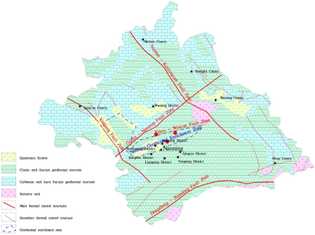
Clastic rock pore-fracture geothermal reservoirs in Guangxi Province. The Nanning Basin geothermal field serves as a representative example. Clastic rock pore-fracture geothermal reservoirs are widely distributed across the whole Nanning area, primarily south of the Guilin-Nanning Fault Zone, covering an outcrop area of 12,970 km2, accounting for 59% of the region. These reservoirs mainly occur in the Paleogene Guting Formation (E2-3g) and the Fenghuangshan Formation (E2-3f).
Guting Formation (E2-3g): The lithology consists of a sequence of thick gray-white quartz sandstone, fine sandstone, and siltstone interbedded with thin layers of silty mudstone and mudstone. The basal section comprises several meters of yellowish-brown, thick-bedded, conglomeratic coarse sandstone or coarse sandstone. The formation thickness ranges from 100 to 220 m, with a porosity of 14.61-19.2%.
Figure 2. Distribution of Geothermal Resources in Nanning City.
Fenghuangshan Formation (E2-3f): The upper section consists of fine sandstone, mud-bearing siltstone, and calcareous fine-siltstone interbedded with calcareous mud-bearing siltstone. The lower to middle sections are composed of calcareous siltstone, calcareous fine sandstone, and calcareous mud-bearing fine-siltstone interbedded with calcareous mudstone. The basal section comprises calcareous, conglomeratic silt-fine sandstone. The formation thickness ranges from 100 to 400 m, with a porosity of 28.68-37.2%.
(2) Karst-fracture geothermal reservoirs in Guangxi are primarily developed in the Upper Devonian Wuzhishan Formation and the Lower Carboniferous Huangjin Formation in the northern Liuzhou area (
Table 1).
Wuzhishan Formation (D3w): Composed of light-gray and dark-gray medium- to thick-bedded lenticular limestone.
Huangjin Formation (C1h): Consists of dark-gray, thick-bedded, fine-grained bioclastic sandy limestone, crinoidal-foraminiferal limestone, and echinoderm-fragment limestone, locally containing siliceous concretion.
Table 1.
Thermal Storage Structure in Northern Guilin . Category | System | Group | Code name | Feature |
topsoil | Quaternary | | Q | Thick: 1.0~30 m |
Normal temperature layer | Carboniferous | Huanglong Group | C2h | Dolomite, thick: 160~180 m |
Tai Po Group | C2d |
Thermal reservoir cap rock | Luocheng Group (Section 3 of Datang Group) | C1l (C1d3) | sandstone, quartz sandstone, mudstone, Thick: 769 m |
Simen Group (Section 2 ofDatang Group) | C1s (C1d2) |
Thermal reservoir | Huangjin Group (Section 1 of Datang Group) | C1h (C1d1) | limestone, mudstone, temperature 40°C ~45°C |
Multi layer reservoir cap rock structure layer | Luzhai Group (Yan Guan Group) | C1lz (C1y) | interbedded with limestone, mudstone, sandstone, and mudstone, thickness 425 m |
Main thermal storage layer | Devonian | Wuzhishan Group | D3w | lenticular limestone, temperature 57°C ~65°C |
Thermal conductive layer | Liujiang Group | D3l | |
Donggangling Group | D2d |
Karst-fracture geothermal reservoirs in Hunan Province are primarily developed within the Upper Devonian Xikuangshan Formation, the Lower Carboniferous Shidengzi Formation, the Upper Carboniferous Hutianqun formations, and the Lower Permian Maokou and Qixia formations.
Upper Devonian Xikuangshan Formation (D3x): The upper section consists of interbedded calcareous sandstone, shale, and thin-bedded argillaceous limestone, with a thickness of 75-236 m. The middle section is composed of gray to dark-gray thick-bedded limestone intercalated with dolomite, while the lower section consists mainly of marl and argillaceous limestone, with a thickness of 72-430 m.
Lower Carboniferous Shidengzi Formation (C1s): The upper section is dominated by gray to dark-gray medium- to thick-bedded limestone interbedded with thin layers of calcareous shale, with a thickness of 145-342 m. The lower section consists of dark-gray, thick-bedded, dense limestone intercalated with dolomitic limestone, with a thickness of 48-110 m.
Upper Paleozoic Hutianqun Formation (CPh): Composed primarily of dolomitic limestone, limestone, and dolomite.
Middle Permian Maokou Formation (P2m): Composed mainly of grayish-white to light-gray, slightly flesh-red, thick-bedded dense limestone and dolomitic limestone, locally interbedded with bands and nodules of chert.
Middle Permian Qixia Formation (P2q): Composed of dark-gray to grayish-black, medium- to thick-bedded dense limestone, locally consisting of fine-grained crystalline limestone.
4.2. Northeast-side Geothermal Reservoirs
1) Intrusive rock structural fracture-type geothermal reservoirs in Guangxi are mainly developed within Yanshanian-period diorite and granite bodies.
2) Pore-fracture geothermal reservoirs in Guangxi are primarily developed within the Neogene Nankang Formation and the Paleogene Shagang and Jiuxikeng formations. The Nankang Formation (Nn) consists mainly of interbedded mudstone and siltstone. The Shagang Formation (E3s) is dominated by interbedded conglomeratic mudstone and conglomeratic siltstone. The Jiuxikeng Formation (N2j) mainly comprises interbedded sandstone and mudstone.
3) Intrusive rock structural fracture-type belt-shaped geothermal reservoirs in Hunan are primarily composed of Silurian biotite granite.
4) Clastic rock fracture-type geothermal reservoirs in Hunan are developed in the Lower and Middle Cambrian (∈1,2). They are mainly composed of low-grade metamorphism sandstone, carbonaceous slate, arenaceous slate, and slate, with a total thickness exceeding 1,053 m.
5. Hydrothermal Characteristics of Springs
5.1. Temperature Field Characteristics of Hot Springs
As shown in
Figure 1, the density of hot springs on the northwestern side of the fault zone is 1.18 springs per 10⁴km
2, which is significantly lower than that on the southeastern side, where it reaches 3.69 springs per 10⁴km
2.
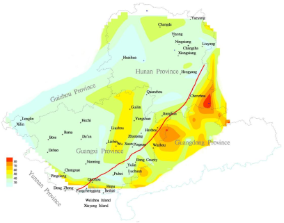
Figure 3 illustrates that the Qinzhou-Chenzhou Fault Zone controls the spatial distribution of spring temperatures across Hunan, Guangxi, and Guangdong. Overall, spring temperatures on the northwestern side of the fault zone are lower than those on the southeastern side. Temperature variations are relatively gentle in the northwest, whereas they are more pronounced in the southeast, with two prominent high-temperature zones located in southeastern Chenzhou, Hunan, and eastern Hezhou, Guangxi. The maximum temperatures in these zones reach 92°C at Ruzhen Hot Spring in Rucheng, Chenzhou, and 83.4 °C at Xixi Hot Spring in Hezhou, respectively. Two secondary temperature peaks are also observed in the Guangdong Ruyuan Yao Autonomous County and Xinyi areas. All four peak zones are distributed in a belt-like pattern along the southeastern side of the fault zone.
Figure 3. Distribution of Spring Temperature (°C).
The data also indicate a temperature-decreasing trend along the fault zone from northeast to southwest. Reshuixu Hot Spring in Reshui Town, Rucheng, Chenzhou, exhibits the highest temperature along the fault zone, followed by Xixi Hot Spring in Hezhou. The Dongzhong Hot Spring at the southwestern end of the fault zone reaches 75 °C, ranking third. All three geothermal reservoirs are hosted in granite, with total dissolved solids in the thermal waters ranging from 135.04 to 351.1 mg/L, suggesting that the hot water is primarily formed by deep circulation of shallow groundwater, and there is little mixing of shallow, low-temperature groundwater.
5.2. Flow Field Characteristics of Hot Springs
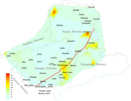
Figure 4 shows that the Qinzhou-Chenzhou Fault Zone controls the spatial distribution of spring discharge across Hunan, Guangxi, and Guangdong, peak spring discharge values occur predominantly near the fault zone, one is located in the Chenzhou area in the northeastern segment of the fault zone, the Chenzhou northern peak zone exhibits the highest spring discharge, the Yushui Hot Spring has a discharge of 231.84 m³/h; however, its temperature is relatively low at only 26°C, the thermal reservoir consists of limestone of the Carboniferous Malanbian Formation (C
1m), and it is structurally well-developed, with well-developed karst fractures, indicating significant mixing with shallow, low-temperature groundwater. In the southern Chenzhou peak zone, the spring discharge reaches 130.68 m³/h, and the temperature—up to 92°C—is the highest around the fault zone, this thermal reservoir is hosted in Middle Jurassic granite, resulting in minimal intrusion of shallow low-temperature groundwater. Another discharge peak occurs in the central segment of the fault zone, extending from Pingnan Guangxi through Rong County to Xinyi Guangdong. At the Nanping Wenshui Hot Spring, the discharge is approximately 130 m³/h, and the temperature is relatively low at 29.8°C, at the Nanping Wenshui Hot Spring, the discharge is approximately 130 m³/h, and the temperature is relatively low at 29.8°C, the thermal reservoir is within the Cretaceous Xinlong Formation (K₁x), where structural deformation is well developed, suggesting significant mixing with shallow, cooler groundwater.
Figure 4. Distribution of Spring Flow (m3/h).
5.3. Hydrochemical Field Characteristics of Springs
Figure 5. Distribution of Total Dissolved Solids in Springs (mg/L).
As shown in
Figure 5, the distribution of total dissolved solids (TDS) in the hot springs is also correlated with the fault zone. Higher TDS values are concentrated on the northwestern side of the fault zone, in central Guangxi, generally exceeding 500 mg/L.Two areas with relatively high TDS values (>500 mg/L) are observed on either side of the Chenzhou section of the fault zone. On the eastern side, the high-TDS zone is located south of Chenzhou, including Yizhang and Lejing in Guangdong, while on the western side, it covers Anren in Chenzhou and Leiyang in Hengyang.
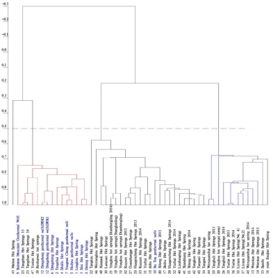
As shown in
Figure 6, correlation coefficient analysis indicates that using a threshold of 0.5, the hot springs near the fault zone can be divided into four groups. The first group includes four hot springs represented by Rushuixu Hot Spring in Rucheng, Chenzhou, Hunan, along with 11 hot springs in Guangxi such as Xixi Hot Spring in Hezhou and Dongzhong Hot Spring, with a correlation coefficient of 0.8 between Xixi and Dongzhong, the correlation coefficients between Rushuixu Hot Spring and Xixi and Dongzhong Hot Springs are 0.79 and 0.78, respectively. The second group comprises the Butou geothermal well in Guangxi and 23 springs in Hunan. The third group consists entirely of 13 springs in Hunan. The fourth group consists solely of Matian Hot Spring. The three high-temperature springs near the fault zone are all included in the first group. This indicates that despite the fault zone’s 800 km length, the nearby hot springs exhibit intricate interconnections. The first and fourth groups are negatively correlated with the second and third groups, primarily due to differences in Li⁺ and F⁻ concentrations among the hot springs.
Figure 6. Cluster Analysis of Spring Water Chemistry.
6. Conclusions
In summary, the Qinzhou-Chenzhou fault zone is the primary thermal control structure in this region, with the following characteristics in its heat storage distribution:
1) On the northwestern side of the Qinzhou-Chenzhou Fault Zone, the karst-fracture geothermal reservoirs account for 56.8% of the total area of 253,500km2.
2) On the southeastern side, pore-fracture geothermal reservoirs dominate, comprising 41.8% of the total area of 52,000km2, followed by intrusive rock structural fracture-type geothermal reservoirs, which account for 36%.
Anomalous zones of spring temperatures are distributed along the Qinzhou-Chenzhou Fault Zone, with a marked difference in hot spring density between the two sides of the fault. Similarly, anomalous zones of spring discharge are also aligned along the fault zone.
The three high-temperature hot springs along the fault zone exhibit strong geochemical correlations, with correlation coefficients ranging from 0.78 to 0.8.
Author Contributions
Xiangming Jiang: Conceptualization, Resources
Xiangqing Fang: Data curation, Methodology
Zhenxing Li: Formal Analysis, Investigation
Zulei Yang: Formal Analysis, Investigation
Pei Wang: Formal Analysis, Investigation
Conflicts of Interest
The authors declare no conflicts of interest.
References
| [1] |
Wang Guiling, Liu Yanguang, Zhu Xi, Zhang Wei. Current Status and Development Trends of Geothermal Resources in China [J]. Earth Science Frontiers, 2020, 27(01): 1-9.
|
| [2] |
Ren Hujun. Progress and Prospects in the Development and Utilization Technology of Medium-Deep Geothermal Energy [J]. China Coal Geology, 2020, 31(S1): 9-11+60.
|
| [3] |
Jiang Xiangming. Dual Development Opportunities for the Coal Industry and Geothermal Sector under the "Dual Carbon" Goals [J]. China Coal Geology, 2022, 34(S1): 1-6.
|
| [4] |
Wang Guiling, Zhang Wei, Liang Jiyun, Lin Wenjing, Liu Ziming, Wang Wanli. Evaluation of Geothermal Resource Potential in China [J]. Acta Geoscientia Sinica, 2017, 38(04): 449-450+134+451-459.
|
| [5] |
Wang Guiling. Strategic Research on Geothermal Resource Exploration and Evaluation in China [C]. China's Geothermal Energy: Achievements and Prospects - Proceedings of the 40th Anniversary Commemorative Conference for Li Siguang's Advocacy of Geothermal Energy Development and Utilization and the China Geothermal Development Symposium, 2010: 55-62.
|
| [6] |
Tian Yong, Wang Weimin, Zhao Yan. Comprehensive Utilization of Geothermal Resources in the Beijing-Tianjin-Hebei Region [J]. China Coal Geology, 2020, 32(02): 51-58.
|
| [7] |
National Energy Administration. Guidelines of the National Energy Administration on Promoting the Integrated and Integrated Development of New Energy (State Energy Administration Document No. 93 [2025].
|
| [8] |
Xiang Song, Golden Water, Wu Bingcheng Mantle convection structural model and its implications for the evolution of Earth's surface structures: a three-dimensional numerical simulation study [J]. Chinese Science: Earth Sciences, 2025, 55(01): 272-298.
|
| [9] |
Luo Fan, Yan Jiayong, Zhang Sheng, etc Thermal structural characteristics and structural indicators of the lithosphere in the South China Block and adjacent areas [J]. Geological Bulletin, 2024, 43(11): 2028-2043.
|
| [10] |
Song Tao, Diao Qian, Zhen Yunqing The relationship between geothermal resources and mantle plume structures in the Qinghai Tibet Plateau: multi-stage evolution of mantle plumes leading to magma intrusion into shallow heat sources [J]. Journal of Hebei University of Geosciences, 2018, 41(06): 1-24.
https://doi.org/10.13937/j.cnki.hbdzdxxb.2018.06.001
|
| [11] |
Yan Zhenzhi, Li Shijiang, Chu Guigang Analysis of Thermal Control Structures in Anshan Tanggangzi Geothermal Field [J]. Geological Exploration Discussion Series, 2003, (S1): 29-31.
|
| [12] |
Xiang Wei Analysis of the Origin and Development Utilization of Geothermal Resources in Sanqiao Area, Guiyang City [J]. Western Resources, 2019, (05): 115-116.
https://doi.org/10.16631/j.cnki.cn15-1331/p.2019.05.048
|
| [13] |
Ye Hongen Exploration of the correlation between geothermal resources, hydrothermal and dry heat systems [J]. Earth, 2019, (06): 102.
|
| [14] |
Wang Chengming, Yang Xunchang, Xu Yong, etc Isotope characteristics analysis of geothermal water in deep karst reservoirs in Shandong Province [J]. Shandong Land and Resources, 2013, 29(01): 21-24.
|
| [15] |
Zhang Senqi, Li Changhui, Sun Wangyong, etc Establishment of Conceptual Model for Thermal Reservoir Structure in Xining Basin [J]. Geological Bulletin, 2008, (01): 126-136.
|
| [16] |
Zhou Xiaocheng, Zeng Zhaojun, He Miao, etc The characteristics of short-term precursor anomalies of Tengchong volcanic hot spring fluid geochemistry earthquakes [J]. Earthquake Research, 2026, 49(01): 51-64.
https://doi.org/10.20015/j.cnki.ISSN1000-0666.2026.0006
|
| [17] |
Su Xiaoyi, Gu Guohui, Pan Xiaodong, etc Characteristics of Carbon Gas Flux near the Tianchi Volcanic Hot Springs in Changbai Mountain [J]. Journal of Disaster Prevention and Reduction, 2025, 41(01): 82-89.
https://doi.org/10.13693/j.cnki.cn21-1573.2025.01.011
|
| [18] |
Chen Yue, Zhu Jinlin, Zeng Jinjin, etc The distribution pattern and controlling factors of hot springs in the complex tectonic zone of Shaoguan, Guangdong [J]. Journal of Chengdu University of Technology (Natural Science Edition), 2023, 50(01): 101-110.
|
| [19] |
Song Yin Research on the Characteristics and Causes of Longling Hot Springs in Yunnan Province [D]. Kunming University of Science and Technology, 2021.
https://doi.org/10.27200/d.cnki.gkmlu.2021.000793
|
| [20] |
Yang Sennan, Yang Weiran Regional Geodesy in China [M]. Beijing: Geological Publishing House, 1985.
|
| [21] |
Zhang Jian, He Yubei, Fan Yanxia, etc Crustal Temperature of the Southern Section of the Tanlu Fault Zone: Geothermal Analysis Based on High Resolution Three Dimensional Velocity Model [J/OL]. Geological Frontier, 1-12 [2021-11-25]
https://doi.org/10.13745/j.esf.sf.2025.3.76
|
| [22] |
Xu Shihong, Zhong Jianhua, Xu Youde, etc Differences in Depression, Source Rocks, and Hydrocarbon Evolution on Both Sides of the Tan Lu Fault Zone [J]. Journal of Chengdu University of Technology (Natural Science Edition), 2007, (05): 505-510.
|
| [23] |
Hu Huaxuan, Qin Ya, Wu Jie, etc The structural properties of the Yingyangguan Group in northeastern Guangxi: Chronological constraints from the banded magnetite quartzite of the Halong Formation [J/OL]. East China Geology, 1-26 [2020-08-22]
https://doi.org/10.16788/j.hddz.32-1865/P.2025.01.007
|
| [24] |
Li Shuai, Wang Fan, Wang Jinchao, etc The characteristics of intra plate deformation and structural transformation in the Qinzhou Lingshan tectonic belt of the southern section of the Qinhang Hangzhou junction zone during the Mesozoic era [J]. Geotechnical and Mineralogy, 2023, 47(03): 523-534.
https://doi.org/10.16539/j.dgzyckx.2023,
03.004
|
| [25] |
Peng Touping, Li Chaowen, Peng Bingxia Structural constraints and exploration indicators of geothermal resources in Hunan Province [J]. Hunan Geology, 2002, (01): 56-60.
|
| [26] |
Wang Xinwei, Zhang Lili, Li Shanmin Analysis of the genesis model of Yangmeichong geothermal field in Guangxi [J]. Chinese Karst, 2024, 43(04): 876-888+921.
|
| [27] |
Wu Weizhi, Mo Yanjuan, Huang Lixia, etc The formation conditions and hydrochemical characteristics of Hetang Hot Springs in Hezhou [J]. Journal of Guangxi Academy of Sciences, 2013, 29(04): 230-234.
https://doi.org/10.13657/j.cnki.
gxkxyxb.2013.04.05
|
| [28] |
He Jun, Liu Huaiqing, Li Qinghua, etc Preliminary exploration of the activity of the Lingshan section of the northeast branch of the Fangcheng Lingshan fault zone in Guangxi [J]. South China Geology and Mineral Resources, 2012, 28(01): 71-78.
|
| [29] |
Wang Jincao, Li Shuai, Huang Guanwen, etc The Geotechnical Significance of the Lingshan Fault Zone in Guangxi: Evidence of the Diagonal Collision between the Yangtze Plate and the Huaxia Plate [J]. Journal of Guilin University of Technology, 2017, 37(04): 738-739.
|
| [30] |
Hu Zhidan, Jiang Haojie, Chang Mengyao, etc The basic characteristics of new structures in Qinzhou, Guangxi [J]. World Nonferrous Metals, 2017, (05): 128+130.
|
| [31] |
Mo Yajun, Qu Xiaoyi, Zhu Guoqi, etc Investigation and Prospect Analysis of Geothermal Resources in the Northern Region of Liuzhou City, Guangxi [J]. Mineral Resources and Geology, 2021, 35(06): 1102-1110.
https://doi.org/10.19856/j.cnki.issn.1001-5663.2021.06.011
|
Cite This Article
-
APA Style
Jiang, X., Fang, X., Li, Z., Yang, Z., Wang, P. (2026). Investigation on the Technological Characteristics of Geothermal Resources in the Qinzhou Chenzhou Fault Zone. American Journal of Energy Engineering, 14(1), 34-44. https://doi.org/10.11648/j.ajee.20261401.15
 Copy
|
Copy
|
 Download
ACS Style
Jiang, X.; Fang, X.; Li, Z.; Yang, Z.; Wang, P. Investigation on the Technological Characteristics of Geothermal Resources in the Qinzhou Chenzhou Fault Zone. Am. J. Energy Eng. 2026, 14(1), 34-44. doi: 10.11648/j.ajee.20261401.15
Copy
|
Download
AMA Style
Jiang X, Fang X, Li Z, Yang Z, Wang P. Investigation on the Technological Characteristics of Geothermal Resources in the Qinzhou Chenzhou Fault Zone. Am J Energy Eng. 2026;14(1):34-44. doi: 10.11648/j.ajee.20261401.15
Copy
|
Download
-
@article{10.11648/j.ajee.20261401.15,
  author = {Xiangming Jiang and Xiangqing Fang and Zhenxing Li and Zulei Yang and Pei Wang},
  title = {Investigation on the Technological Characteristics of Geothermal Resources in the Qinzhou Chenzhou Fault Zone},
  journal = {American Journal of Energy Engineering},
  volume = {14},
  number = {1},
  pages = {34-44},
  doi = {10.11648/j.ajee.20261401.15},
  url = {https://doi.org/10.11648/j.ajee.20261401.15},
  eprint = {https://article.sciencepublishinggroup.com/pdf/10.11648.j.ajee.20261401.15},
  abstract = {The Qinzhou Chenzhou Fault Zone is the junction zone between the Huaxia Block and the Yangtze Block. It is of great significance for how geothermal resources are controlled and for in-depth research on structural heat control. Starting from geothermal geological analysis, this article systematically analyzes and studies the types of thermal reservoirs, hot spring distribution, spring temperature field distribution, spring flow field distribution, and spring chemical field distribution on both sides of the Qinzhou Chenzhou Fault Zone. The results indicate that the Qinzhou Chenzhou fault zone has a significant controlling effect on geothermal resources in the Hunan Guangxi region. The northwest side of the fault zone is dominated by sedimentary thermal reservoirs, while the southeast side shows a decrease in the distribution of sedimentary thermal reservoirs, which is basically equivalent to intrusive rock structure thermal reservoirs; The anomalous thermal field of the springs is distributed along the Qinzhou-Chencheng fault zone, with a significant difference in the density of hot springs on either side of the fault, The density of hot springs on the northwest side of the fault zone is 1.18/104km2, which is lower than that on the southeast side, which is 3.69/104km2; The chemical correlation coefficients of the three high-temperature hot springs are 0.78-0.8.},
 year = {2026}
}
Copy
|
Download
-
TY  - JOUR
T1  - Investigation on the Technological Characteristics of Geothermal Resources in the Qinzhou Chenzhou Fault Zone
AU  - Xiangming Jiang
AU  - Xiangqing Fang
AU  - Zhenxing Li
AU  - Zulei Yang
AU  - Pei Wang
Y1  - 2026/02/28
PY  - 2026
N1  - https://doi.org/10.11648/j.ajee.20261401.15
DO  - 10.11648/j.ajee.20261401.15
T2  - American Journal of Energy Engineering
JF  - American Journal of Energy Engineering
JO  - American Journal of Energy Engineering
SP  - 34
EP  - 44
PB  - Science Publishing Group
SN  - 2329-163X
UR  - https://doi.org/10.11648/j.ajee.20261401.15
AB  - The Qinzhou Chenzhou Fault Zone is the junction zone between the Huaxia Block and the Yangtze Block. It is of great significance for how geothermal resources are controlled and for in-depth research on structural heat control. Starting from geothermal geological analysis, this article systematically analyzes and studies the types of thermal reservoirs, hot spring distribution, spring temperature field distribution, spring flow field distribution, and spring chemical field distribution on both sides of the Qinzhou Chenzhou Fault Zone. The results indicate that the Qinzhou Chenzhou fault zone has a significant controlling effect on geothermal resources in the Hunan Guangxi region. The northwest side of the fault zone is dominated by sedimentary thermal reservoirs, while the southeast side shows a decrease in the distribution of sedimentary thermal reservoirs, which is basically equivalent to intrusive rock structure thermal reservoirs; The anomalous thermal field of the springs is distributed along the Qinzhou-Chencheng fault zone, with a significant difference in the density of hot springs on either side of the fault, The density of hot springs on the northwest side of the fault zone is 1.18/104km2, which is lower than that on the southeast side, which is 3.69/104km2; The chemical correlation coefficients of the three high-temperature hot springs are 0.78-0.8.
VL  - 14
IS  - 1
ER  -
Copy
|
Download